A woman hiking Kungsleden. A majestic view of the mountains, fields and two rainbows.
Hiking
Kungsleden (from Abisko to Hemavan) is one of the world’s most famous hiking trails. The path is more than 450 kilometres long, and was established by STF in the beginning of the 20th century. Kungsleden passes through varied landscape in the Lapland mountain world, through four national parks: Abisko, Stora Sjöfallet, Sarek and Pieljekaise. There are dramatic changes along the way between alpine terrain and low-lying mountain birch forest.
Photo credit: Wangkun/Fjällräven/imagebank.sweden.se

Hiking the King's Trail (Kungsleden)

Hiking the King’s Trail (Kungsleden) is one of Sweden’s classic outdoor experiences. Stretching across Arctic Sweden, this long-distance route passes through vast mountain landscapes, four national parks and the UNESCO World Heritage Site Laponia.

With several starting points along the route, it’s easy to tailor the hike to suit your time, experience and interests.

The King’s Trail was created by the Swedish Tourist Association (STF) in the early 1900s. The idea was to make the Swedish mountains accessible while guiding visitors through the region’s most beautiful landscapes – hence the name, ‘the king of trails’.

Today, Kungsleden is one of the world’s most well-known long-distance hiking routes.

Along the way, the scenery shifts constantly. One day you might walk through open alpine terrain with sweeping views of distant peaks, the next through quiet birch forests or across wide valleys dotted with lakes and rivers. Small mountain villages appear occasionally, but long stretches feel remote and peaceful. The trail passes through four national parks (Abisko, Stora Sjöfallet, Sarek and Pieljekaise) as well as the UNESCO World Heritage Site of Laponia.

Maps require approval for third-party cookies (Targeting) from Google. Modify cookie settings by clicking the icon at the bottom left. Click "Show map once", to accept Google's terms once.

How long is the King’s Trail?

The King’s Trail stretches for around 450 kilometres and takes about a month to hike in its entirety. If you don’t have that much time, the trail is divided into five sections, making it easy to choose a shorter hike depending on your schedule and preferred scenery.

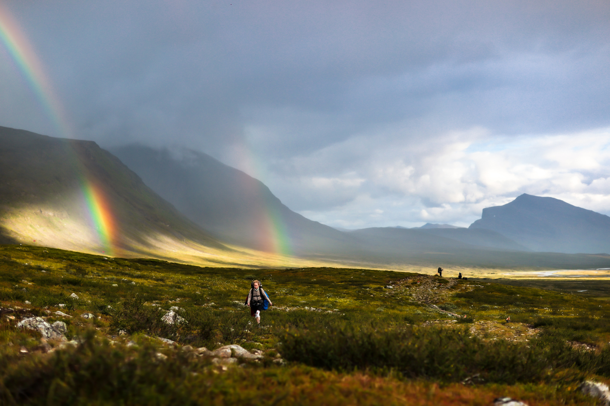
The most popular stretch is the northernmost section, running between Abisko and Nikkaluokta. This 107-kilometre route usually takes five to seven days and passes some of Sweden’s most iconic mountain scenery, including the dramatic Lapporten valley and Sweden’s highest mountain, Kebnekaise.

Where to start hiking the King's Trail

The most common starting point is Abisko, located at the northern end of the trail. Many hikers begin at STF Abisko Turiststation and head south.

Abisko is easily reached by overnight train from Stockholm, operated by SJ. You can also travel here by train or bus from Kiruna, about one and a half hours away.

Other starting points along the trail include Nikkaluokta, Saltoluokta, Kvikkjokk, Ammarnäs and Hemavan. All have STF mountain cabins nearby.

A group of people hiking Kungsleden, with a majestic background of mountains, cloudy skies, fields, sunshine.

Hiking

Kungsleden (from Abisko to Hemavan) is one of the world’s most famous hiking trails. The path is more than 450 kilometres long, and was established by STF in the beginning of the 20th century. Kungsleden passes through varied landscape in the Lapland mountain world, through four national parks: Abisko, Stora Sjöfallet, Sarek and Pieljekaise. There are dramatic changes along the way between alpine terrain and low-lying mountain birch forest.

Photo: Wangkun/Fjällräven/imagebank.sweden.se

How difficult is the King's Trail?

Despite being located above the Arctic Circle, the King’s Trail is considered accessible for many hikers. The relatively moderate elevations, clearly marked paths and well-maintained trails make large parts of the route suitable even for beginners with good fitness. Families with older children also hike sections of the trail, though it’s wise to plan shorter distances and allow more time when travelling with younger hikers.

Staying in mountain huts instead of camping also allows you to carry a lighter backpack.

What to pack for hiking Sweden's King's Trail

Weather in the Swedish mountains can change quickly, and rain is common even during summer. Waterproof hiking boots, a rain jacket and waterproof trousers are essential.

Other useful items include:

  • Walking poles for muddy sections and stream crossings
  • A warm sleeping bag and sleeping mat if camping
  • A portable stove and cooking equipment
  • Plenty of dry food
  • A first aid kit
  • Insect repellent – mosquitoes can be plentiful in northern Sweden

Food can be purchased in many STF huts, but prices are higher than in supermarkets, so most hikers bring part of their supplies.

A small but helpful tip is to bring a few extra bags so you can carry your waste with you. It’s important to leave the landscape as clean as you found it.

Majestic landscape view of Kungsleden. River surrounded by mountains, cloudy sky and sunshine.

Kungsleden

Kungsleden (from Abisko to Hemavan) is one of the world’s most famous hiking trails. The path is more than 450 kilometres long, and was established by STF in the beginning of the 20th century. Kungsleden passes through varied landscape in the Lapland mountain world, through four national parks: Abisko, Stora Sjöfallet, Sarek and Pieljekaise. There are dramatic changes along the way between alpine terrain and low-lying mountain birch forest.

Photo: Wangkun/Fjällräven/imagebank.sweden.se

Where to stay along the trail

The Swedish Tourist Association (STF) operates 16 mountain cabins along the King’s Trail. These simple but comfortable huts provide a mattress, pillow, blanket and basic cooking facilities. Many also sell food supplies.

The cabins are typically spaced 10–20 kilometres apart, making them convenient stopping points for a day’s hiking. Between Kvikkjokk and Ammarnäs there are no STF cabins, but some other limited accommodation options can be found along this section.

Good to know before you go

Reindeer herding takes place in the mountains along the King’s Trail. Keep a respectful distance and avoid disturbing or stressing the animals.

Other useful things to keep in mind:

  • Mobile reception can be limited in parts of the mountains, so it’s a must to bring a map and compass.
  • Weather can change quickly, even in summer. Be prepared for sun, rain and even snow.
  • Some sections of the trail require rowing boats to cross lakes.
  • Water from streams is generally safe to drink.
  • The STF mountain cabins are popular, so book in advance.

For more information about the King’s Trail and its different sections, visit the STF website.

Majestic reindeer surrounded by fields, mountains, heavy clouds and sunshine.

Reindeer

Kungsleden (from Abisko to Hemavan) is one of the world’s most famous hiking trails. The path is more than 450 kilometres long, and was established by STF in the beginning of the 20th century. Kungsleden passes through varied landscape in the Lapland mountain world, through four national parks: Abisko, Stora Sjöfallet, Sarek and Pieljekaise. There are dramatic changes along the way between alpine terrain and low-lying mountain birch forest.

Photo: Wangkun/Fjällräven/imagebank.sweden.se

A lesser-known alternative: the Southern King's Trail

If you’re looking for another long-distance hike in Sweden, the Southern King’s Trail (‘Södra Kungsleden’) offers a quieter alternative.

This route stretches for around 350 kilometres from Sälen in Dalarna to Storlien in Jämtland. While it was originally part of a plan in the 1970s to extend Kungsleden along the entire Scandinavian mountain range, the project was never completed.

What remains today is a scenic and quieter hiking route. The terrain is relatively gentle and suitable for many hikers. Highlights along the trail include Njupeskär, one of Sweden’s tallest waterfalls, and Idre, the southernmost Sámi village in Sweden.